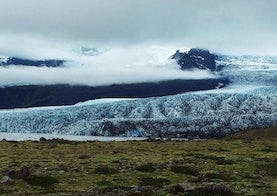
Fjallsárlón
This hiking trail goes along Fjallsárlón where you can admire the beautiful lagoon and Fjallsjökul.
The trail starts on the west side, behind the restaurant Frost, where you can see an educational sign with information about the area. From the educational sign, a marked gravel path leads down to Fjallsárlón. On the way down to the lagoon, you come to a viewpoint where you can look over Hrútárjökull, Ærfjall, Fjallsjökull, Breiðamerkurfjall and Fjallsárlón. Then continue along the path, but just before reaching the lagoon, there is another marked path that leads east, all the way to Jökulsárlón. Instead of turning this trail to the right, continue along the reservoir until it turns slightly to the left and you climb a small hill. When you get to the top of the hill you can see a road that used to be the main road. Follow it until you get back to the restaurant and the parking lot.
Hiking
